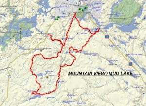
TRACK: MOUNTAIN VIEW / MUD LAKE
AREA: Region: Sturgeon Falls, Field & Marten River
Marten River, Pike Lake Road, Hwy 64 triangle
DISTANCE: 75 km.
RATING: 3.0 in general and 4.5 in some trails.
ACCESS: Drive from Field on Hwy 64 approximately 20 km. towards Marten River and Hwy. 11 N. At Mountain Home Lodge on Holdridge Creek turn right on McLaren Road. Just a short distance there is a large area to park.
TRACK DESCRIPTION:
– Travel 4.5 km. along McLaren Road to the Pole line. The going is excellent.
– From here turn north and travel 7.5 km. along the pole line to Hwy. 64. In 2016 work was done on the transmission lines and Hydro maintained the trail so going is good.
– From Hwy 64 turn right and travel SE crossing a large swamp. The gravel bottom guarantees good going. A little further there is a hunt camp from which we can see Marten River Provincial Park.
– 1.0 km. from here the trail has been washed exposing rocks and boulders. Caution is advised.
– Continue on to Finlayson Lake and a beautiful sand beach.
– At the next fork turn left. Continue on to the main road. Turn left and travel 1.5 km ending up at Hwy 11N.
– Turn north on HWY 11N and stop at the Rock Pine Motel and Restaurant just up the road.
– The return route follows the same path until you come to the fork that came from Finlayson Lake but continue straight ahead to Camp Nine Lake. This is a beautiful spot to stop and is considered a choice place to camp.
– Follow the trail to a fork in the road. Straight ahead will lead us back to our vehicles. Turn left, crossing the Holdridge Creek bridge and continue 4 km. to another major fork. Straight ahead leads to a hunt camp and the King Run.
– Turn right and continue approximately 3 km. to the pole line.
– Turn left here following the pole line to Pike Lake road and to the turnoff for the Sugarbush ride. Go up this road to Mud Lake turning left at the fork.
– From here you should follow your GPS as the trail winds through brush and cutover areas and continue on to nearly the Langevin camp as shown on the map. Just before this make a right turn and follow the road and into a cut road right of way.
– This is where the trail become windy and narrow and can be classified a 4.5. It’s slow going but in mixed wood mostly white birch. This continues for 1 km. Then we meet a nice bush trail continue on to the main trail, turn left to the bridge over Holdridge Creek. A little further we meet the trail taken in the morning and by turning left we continue on to our parking area.
01/18/2020