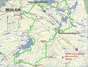
TRACK: MEGA RUN
AREA: Region: Sturgeon Falls, Field & Marten River.
Tomiko & Marten Lake Area
DISTANCE: 155 km.
RATING: 5
ACCESS: Drive to Riding Stable road (13 km east of Sturgeon Falls) off of Hwy 17. Head north, for about 5 km to a parking area at a sand pit near the pole line.
CAUTION: The last time this ride was travelled by the club in certain areas was 2014. There are challenging spots so beware of the hazards.
TRACK DESCRIPTION:
– From the parking area head 6 km. north to the bridge over Smokey Creek. Turn left to Crystal Falls following Dubuc Road and continue on to Tomiko Road.
– Turn right (north) and follow Tomiko Road to the end, approximately 9 km. Continue straight ahead following an old logging road.
– The next section to Mosquito creek can be rough and muddy depending on the weather. It can make for slow going. This is part of the King Run.
– The crossing at Mosquito creek can be easy with about 2 feet of water.
– Once over the creek the trail divides at considerable blow down. We turn right and continue on to a hunt camp. This section can be challenging.
– From here we follow the track on a very nice trail. Some of it is road but mostly it is a path and very good going. Turn left (east) approx. 2 km. along. Right leads to Holditch Lake and Hwy. 11N. Continue on 5 km. to another fork. Turn right (north) to Holdritch Creek. Left brings us to the pole line and eventually Pike Lake. At Holditch Creek, cross the bridge and at the immediate fork turn right (east) and follow the trail to Hwy 11 N. Approx. 8 km.
– At the Rockpine Restaurant we have lunch and can fill up with gasoline.
– Continuing, cross Hwy 11 N following the road to Beaverland Lodge. At the pipeline turn right and we will follow this to the Bidwell Road, close to 3 km. away. Caution in a few spots especially at #1 on the map because of deep water conditions. Track in the middle of the trail.
– From here follow the directions for the Bidwell Ride and at # 2 on the map look out for the beaver dam. Go with caution. Remember to make reservations at the Tomiko Restaurant for supper because they can close at 6:00 pm.
– From here we follow a short cut that crosses Hwy 11N and brings us to the pipeline. (see #3 on map). Turn left (south) and follow the pipeline to a fork leading to Tomiko Lake.
– Turn right and continue SW 7 km. Turn left (south), crossing the washed out culvert, then over the Tomiko River Bridge and finally to the path leading back to Riding Stable Road.
– From here we follow the road back to our parking area arriving up to 10 hours later.
Revised 01/19/2018