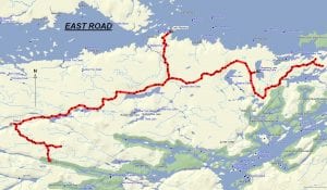
TRACK: EAST ROAD
AREA: Region: Hwy. 17 South
East of North Monetville
DISTANCE: 87 km.
RATING: 2
ACCESS: Drive to North Monetville on Hwy 64 South, passing through the towns of Verner and Lavigne. Turn east on East Road and drive 6 km to a parking area near Perch Lake (room for 5 or 6 vehicles with trailers).
TRACK DESCRIPTION:
– From the parking area turn right and travel nearly 8 km. to the Little French River. You will find a cottage here on the long narrow waterway.
– Return back to the parking area. This 16 km. part of the ride can be omitted if desired.
– Turn left and travel the first 20 km. on a well maintained road (it can be very dusty at times, so bring a mask and goggles in case). You will pass by 2 substantial lakes, Porcupine and Rabbit, before reaching the biggest lake, Number One Lake. This is a popular camping area with a small boat launch. Nice place for a picnic.
– Approximately 3 km. further there is a fork in the road. To the left (north), past Number One Creek, there is an access road to Lake Nipissing (sign: Hidden Camp). At the end of this road is a panoramic view of Hay Narrows, the start of the West Arm, Kervin’s Island and in the distance the Bald Rocks and Iron Island. Nice place for a picnic and photos.
– Returning to the fork above, continue east on the main road passing by the access road to Redpine Lake. This road can have a lot of water at certain times of year.
– Continue on to Obashking Lake, where there is a camping area and the remnants of an old hunt camp. This is where the main road ends a trail starts.
– Heading south and east on this trail through a nice pine forest, you will pass near Marsh Bay on the French River. Then heading northeast, the trail has become overgrown with brush and at one time you could see Sandy Island on Lake Nipissing, close to Forestry Island. This is where you should turn around for the return trip since there isn’t much to see.
– Just before returning to the parking area, there is a fork with a road heading south (near Perch lake). This road eventually reaches the Hall River (Little French) in about 3.5 km. This is another side trip time permitting.
HISTORY: This road has been constructed for logging by Davidson Lumber of Sturgeon Falls and Fryer Lumber of Monetville. For the residents in this area this road has always been an exceptional means to go camping and fishing on crown land. Also the area is noted for deer and moose hunting in the fall. The last time the club held a ride here was 2017.
01/16/18