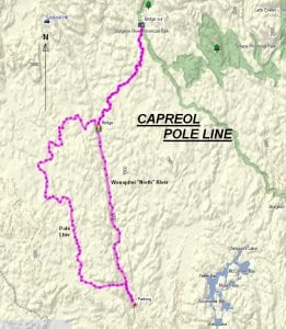
TRACK: CAPREOL POLE LINE
AREA: Region: Capreol North
North of Capreol
DISTANCE: 110 km
RATING: 3
ACCESS: You can access this ride by travelling to Capreol.
1. From Capreol travel approximately 7 km. on highway 545.
2. Turn right on Portelance Road. At the corner it says to Rocky’s and to the Wanapitei Reserve. Travel approximately 7 km.
3. Continue straight, not turning at Rocky’s turnoff, on Gauthier Lumber Road for 20 km. to the parking area.
TRACK DESCRIPTION:
– This ride follows the Wanapitei River for close to 30 km. Locals call this the North River.
– Cross the bridge and continue on to the head waters of the Sturgeon River. The bridge has been removed and you can’t go any further.
– Return back on your tracks to the bridge crossing the North River and turn to the right and effectively follow the pole line back to the parking area.
– Most of the trail on the pole line is forested.
It might be advisable to bring extra gas.
This ride is a new one to the club.
01/19/2018