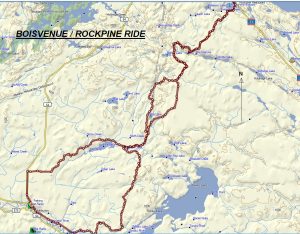
TRACK: BOISVENUE / ROCKPINE RIDE
AREA: Region: Sturgeon Falls, Field & Marten River
Field northeast to Marten Lake
DISTANCE: 75 km.
RATING: 3 (see cover letter) wnatvclub.ca
ACCESS: From Field or leaving Sturgeon Falls via Clear Lake Road.
TRACK DESCRIPTION:
– From Field travel 5.5 km. S.E. following the abandoned railway track and just before the bridge crossing the Sturgeon River turn left. Travel east for 3 km. following an old logging road. For the next 5 km. follow the snowmobile trail. Some places are beautiful with the pure maple bush. There are two spots that are muddy and caution should prevail.
– Once meeting the pole line, follow this right through to the extension of Pike Lake road. This is where the ride meets up with the Rockpine Run. If you wish, you can continue on down Pike Lake Road to Hwy. 64 and Field. This makes for a short but interesting day.
– Before the creek on Pike Lake Road, make a right, at the first fork. Pass through a red pine plantation and head northeast to the Pole Line and Rat Lake. Keep going until you come to a large open spot where the Field rally sets up their hot dog stand. Here, turn right and leave the pole line heading east.
– At approximately three km. there is a trail to the right which will be taken on the return trip. Continue straight ahead and at six km. turn left at the fork. Right will lead to a hunt camp and follow the King run.
– Cross the bridge spanning Holdridge Creek and a short distance away, you will reach a road going east-west. If you turn left this will bring you to Hwy 64 and Mountain Home Lodge. Turn right (east) and this will bring you near Camp Nine lake. This is a beautiful spot to stop and is considered a choice place to camp. Continue on the main road which turns northeast for 5 km. and ends up on Hwy 11N.
– Drive north along Hwy 11N to Rockpine Restaurant to have lunch.
– The return route follows the same path until you come to the fork mentioned above between the turn off to the King run and the Pole line. This is an alternate route for the King Run. On the map you can see the red line. Turn left and take this route back, crossing the edge of a swamp and coming close to Mayotte’s camp. This had burnt down several years ago but is now rebuilt.
– Continue on until meeting the main road. Stay right and continue straight ahead until meeting the Pike Lake road. Head now to Hwy 64 N and the parking spot in Field where the ride started.
Revised 01/19/2018