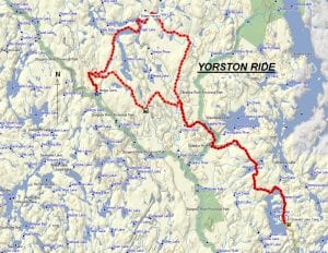
TRACK: YORSTON RIDE
AREA: Region: Hwy 805 North Northwest of Emerald Lake
DISTANCE: 107 km.
RATING: 3
ACCESS: Drive to Manitou Lake RV Park situated on Manitou Lake. Previously parking was at Blue Demon Lodge or Emerald Lake camp but space is limited. All are approximately 1.75 to 2 hours from Sturgeon Falls.
TRACK DESCRIPTION:
– Leaving our parking area, follow Hwy 805 passing Emerald Lake, Iron Lake to the Obabika River. – If you turn left this leads to the Sturgeon River and Goose Falls. Continue straight, crossing the river and heading north to the road turning right to Twinkle Lake. On the way do not take any roads crossing the Yorston River. – Immediately, we go down a steep hill where caution is advised. – Continue on to Twinkle Lake. This is a beautiful scenic spot for a break. – Follow the trail to Seagram Lake and Linger Lake, a good spot for lunch. Just before this the trail follows in a small stream which depending on the rainfall could be as deep as 4 feet. On the map it is noted as a water hazard. Usually you can get by but it should be a concern and if the ride is sponsored by the club, this is checked beforehand. – Continue on north of Yorston Lake through an old burn and head south. At the major fork in the path turn right. Just a short distance you hit a “T” in the trail. Right will lead to Pilgrim Creek and Bull Lake. Turn left and continue to the Sturgeon River. One time there was a bridge here but now it’s washed away. Enjoy the rapids for this is the end of the line. – Return back on your tracks keeping to the right and the trail continues south east. The trail is nice going with picturesque trees. Cloutier hill is rocky and slow going but the colour of the white birch trees is outstanding. Continue on to the Yorston River. – Just before this you can turn right and this leads to the Sturgeon River or as old timers would say “Vietnam”. At low water you can cross here. This is mentioned in the Alma Camp ride. – The road to the left before the river leads to a series of hunt camps. – Once we cross the bridge over the Yorston River we meet the main trail that we took in the morning. Following the same path to return to the parking area. This can be dusty as it is later on in the day and the trail is much drier.
HISTORY: The club has had numerous organized rides in this area. The whole area has been logged for many decades by Goulard Lumber from Sturgeon Falls. It is an exceptional region for camping and ATV’ing because of the numerous roads and lake access. It is not uncommon to meet friends and neighbours from the West Nipissing Community on a days ride.
The last time the club organized a ride here was 2012.
Revised 01/16/2019