Tilden Lake Ride:
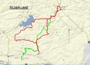
TRACK: TILDEN LAKE RIDE
AREA: Region: Sturgeon Falls, Field & Marten River
Sturgeon Falls or Jocko Point northeast to Tilden Lake
DISTANCE: 92 km or 75 km depending on the parking point.
RATING: 3
ACCESS: – Parking S.F. On highway 17 turn left 3 km. from Sturgeon Falls on Sandy Falls Road. Parking may be done anywhere along this road. Some bikers follow the ditch along the highway from Sturgeon but this is illegal and charges can be laid by the OPP. We attempted this section of the ride in 2019 and had to abandon it because of beaver activity just before Riding Stable Road. This section has definitely a 4.5 difficulty rating.
– Parking Riding Stable Rd. Drive to Riding Stable Road (13 km east of Sturgeon Falls) off of Hwy 17. Head north for about 6 km to a parking area at the pole line.
TRACK DESCRIPTION:
– S.F. From Sandy Falls road, follow the Sturgeon River. 1.5 km. from the gravel pit there is a fork in the trail. A left turn will bring you to the Sandy Falls.
– Continue straight ahead crossing the abandoned rail line. Follow the logging road heading north for approximately 3 km. At N 46 25’50.27” W 79 50’14.09” make a sharp right. This can be easily mistaken but look out for tire tracks. This trail is rough and caution is advised. You will cross a small creek and continue on into a clear cut.
– At the logging road, turn right, then a left, heading towards Riding Stable road. There could be a beaver dam here flooding the trail.
– This is where you meet the track from the second parking area.
– At riding Stable road head north crossing Smoky creek. Continue straight ahead.
– Approximately 2 km. there is an intersection, turn right. You can continue straight ahead this follows the green track on the map and comes out further up on our ride. This however, is challenging and can be rated a 5.
– At the next intersection turn left. Right will lead you to our Sand Dam ride. The trail has been bulldozed into a logging road right through to the Tomiko River.
– Continue on crossing the Tomiko River Bridge. 2 km. on you can turn right. This comes out further ahead on the Tilden Lake trail and is coloured green on the map. Going is a 4. However, continue straight ahead until we hit a “T”.
– Turn right and follow the trail to Hwy 11 north. The scene is picturesque at times with the hardwood forests. Near Tilden Lake cross over the bridge for if turning left this will lead to the pipeline and our return trip.
– At Ellsmere Village cross over HWY 11 to the Tilden Lake restaurant for lunch.
– To return, follow hwy, 11, heading north maybe 1000 feet, cross over and head west to the pipe line. Turn left and go 1 km. to meet the trail coming in.
– Follow the trail back to the “T” mentioned above. Here, continue straight ahead to Tomiko Lake. The ride is a little rougher.
– Turn left and continue on to Tomiko road. Turning right will lead to the King Run. Follow the road right through to the Sturgeon River, a distance of 9 km.
– Turn left and continue through Crystal Falls and travel 7.5 km. to Smoky Creek. Follow the trail back to our parking areas.
NOTE: Because there are really two ways to do this ride there are two gpx files: Tilden one and Tilden two.
01/16/2020