
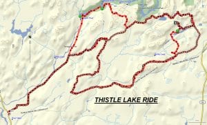
TRACK: THISTLE LAKE RIDE
AREA: Region: HWY 64 North & River Valley North of River Valley
DISTANCE: 51 km.
RATING: 3 (see ratings below) wnatvclub.com ACCESS: Drive to River Valley (a 35 km. drive north of Sturgeon Falls) and park at the empty lot next to the school and church.
TRACK DESCRIPTION:
– Drive 8 km. up St. Joseph Road towards the Temagami River passing Gibbons Road. Where the farmland ends you will see a trail heading east. Turn right and continue on, crossing numerous beaver dams. Throughout the ride you will notice considerable beaver activity. At approximately 4 km. turn right onto a nice trail which can be missed so be on the lookout. – Follow the well-used trail which eventually leads into a cut over and to the main Gibbons Forest Access Road. Here turn left and follow this road 9 km. to maybe 2 km. before the Island Lake Road. This is where you have to make a decision. – Make a left and this trail will lead us to a beautiful spot for lunch. However, beavers have been active so if you hit a deep water hole turn around and go back to the main road. – Follow the main road to Island Lake Road and turn left. Travel 2 km. and turn left following the trail staying to the left at all times. You will arrive at the same beautiful spot for lunch as mentioned above. Notice the remanence of a cement foundation from an old camp that once housed the fire rangers. – Return on the trail for 1 km. and then make a left. This will bring us to a fire tower. Going is steep so caution is advised. This is the tower that at one time was going to be moved to Field as a tourist attraction. – Return to the main trail, turn left and this will bring us to Island Lake road. – Turn left and travel a short distance to a large parking area. – At the gravel pit you will notice the painted rock that looks like an eagles head. Head west to the far end of the pit and follow the trail. This will lead you to a small unnamed lake. Notice how red pine trees have been planted along the way. – Continue on until we come to a fork in the road. Going straight will lead us to the trail taken in the morning and to St. Joseph Road. – Turn right and follow the trail which was once used by the River Valley rally. Go slow because the way is rough, rocky and requires caution. – Approximately 3 km. the trail starts following the Temagami River. Follow it to the Lavergne Rapids and enjoy a welcomed rest. This section can be muddy depending on the weather. – Continue on through red pines, following the river. At the Main road there is an excellent spot for a break. – Turn left heading southwest towards River Valley and to the parking area. It is difficult to describe the ride and it’s advised to make use of the map or better still a GPS.
HISTORY: This area has been logged over many times mostly by the Giroux-Vezina and is presently in a state of regeneration. We did notice that Goulard Lumber has started to cut in some spots. It’s noted for a variety of conditions and beaver activity.
Revised 01/16/2019