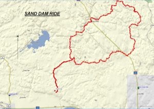
TRACK: SAND DAM RIDE
AREA: Region: Sturgeon Falls, Field & Marten River
Northeast of Riding Stable Road.
DISTANCE: 107 km.
RATING: 4
ACCESS: Drive to Riding Stable road (13 km east of Sturgeon Falls) off of Hwy 17. Head north, for about 6 km to a parking area at the pole line.
TRACK DESCRIPTION:
– From the parking area head north to the bridge over Smoky Creek. To the left leads to Crystal Falls. Continue straight ahead.
– Approximately 2 km there is an intersection, turn right. If you continue straight ahead this follows a route which will come out further up on our ride back. This however, is challenging and can be rated 5.
– At the next interection continue straight. Left leads to the Tomiko River. There has been some new logging activity here and the once narrow trail is now a logging road. The turnoff to Sand dam is marked with a red flag on the map and is about a km. from the fork. The trail is not clearly marked so take care. For 2 to 3 km the going is slow.
– Crossing the swamp, you can stop at a hunt camp for a break.
– Continue on to Blyth Lake which can be another stopping point and another camp.
– The road continues on to Hwy 11 north. At times going is slow because of rocks and muddy sections.
– Follow hwy 11N south a short distance to Sand Dam road.
– From here you continue on Sand Dam road, past the Merrick Landfill site and then head north by northeast around Notman Lake. This is a good logging road.
– Noble Lake is a good stopping point, for you go between two lakes and the view is excellent. Caution up to this point because of the numerous side roads that you encounter.
– Continue on west to Tilden Lake and have coffee at the restaurant there.
– Cross hwy. 11 N, go through Ellsmere Village and back to the Tomiko River. The fork straight ahead will lead to Lake Tomiko.
– Turn Left, crossing the washed out culvert, then the Tomiko River bridge and finally to our initial path this morning.
– From here we follow the trail back to our parking area.
HISTORY: The Sand Dam ride is not used often because of the difficulty to get to hwy 11 from this route. Also there has been much logging activity making the ride less attractive. The last time the club wen t on this ride was 2016.
Revised 01/14/18