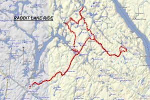
TRACK: RABBIT LAKE AREA
AREA: Region: Temagami / Temiskaming / Mattawa
East of Hwy 11N, south of Temagami
DISTANCE: 92 km
RATING: 2.5
ACCESS: Drive 21 km on Hwy 11 North past the Marten River turnoff, and turn right on Rabbit Lake road at Gramp’s Place. Drive on a good forest access road for 6 km parking in an open area at the turn off to the Rabbit Lake boat launch.
TRACK DESCRIPTION:
– From the parking area, head north 0.6 km for a quick peek at the Southwest Access to Rabbit Lake where there is a dock and boat launch. Then return to the parking area and head east (turn left) for 9 km on the access road arriving at Moosehead Lake, a very scenic picnic area.
– Keep going east for another 5 km, crossing a bridge with Burwash Lake on your right and Ross Lake on your left. Turn left after the bridge, and head northwest for 1 km on a good trail. At the fork, keep to your left and this will bring you to a very scenic spot at the Southeast Access to Rabbit Lake and the site of a man-made earth dam. This is an excellent spot for a break. In 2019 this area was off limits because of construction and repairs to dams in the area.
– Return to the above fork and turn left, and head north. The forest has numerous hardwoods and scattered pines. Approximately 7 km. you will reach a very scenic waterfall called Rabbit Chute. Here you can see a very ingenious rail system to span the gorge and reach a cottage on the other side. There is lots of white water. However in 2019 just before the chutes the trail was flooded and we had to turn back and cancel the ride. This was because of beaver activity.
– Ride northeast along the Mabitchuan River for 1.7 km and at the fork turn left. Another 0.6 km and you reach an access to the Mabitchuan River, a perfect place to pitch a tent and cast for a few trout.
– Return to the fork, and head southeast for 1.5 km passing along Francis Lake. Head northeast for another 1.6 km to another fork in the road. Turning left will bring you to the Mabitchuan River. Turn right, for 0.5 km and cross a very unusual rock bridge with a very solid bottom and big rocks to the side, damming the creek going into Cooper Lake. This is a very unusual formation. Turning left will lead to a boat launch to Cooper Lake. Head straight ahead (southeast), passing Glasford Lake and at 5 km. you will rejoin the Rabbit Lake Road.
– Turn left and continue on Rabbit Lake Road to Maxam Lake, a pickerel lake with a small boat access. Following the main road will eventually bring you near Owain Lake. Beyond this is a restricted area for motorized vehicles but a 4 km. walk will bring you to Grand Campment Bay on the Ottawa River.
– At the next intersection turn right and travel 20 km. back to the parking area.
.
HISTORY: There has been extensive logging in this area. Goulard Lumber in the 80’ies were subject to environmentalist chaining themselves to trees as a protest to cutting old growth forest. This was at the time national news. The last time this ride was done was in 2016.
01/15/2020