
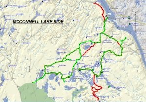
TRACK: McCONNELL LAKE RIDE
AREA: Region Temagami / Temiskaming / Mattawa
North of Eldee (near Temiscaming)
DISTANCE: 85 km.
RATING: 2
ACCESS: From North Bay, drive 51 km on Hwy 63 (going to Temiscaming) and turn left on McConnell Lake Rd heading north for 27 km to an open area at a ‘T’ in the road. This is an excellent parking area.
TRACK DESCRIPTION:
– Head west on a good road for 8 km passing near McConnell and Serene Lakes up to a fork in the road. Turn right and head north for 1.5 km. (Turning left will pass by Boland Lake and bring you to the Pole Line, where there is a trail continuing across a swamp and beyond, possibly to Otter Lake and our Bidwell Ride).
– Once you reach the next fork, keep to your right on a good trail for 2.2 km, and then turn right for another 2 km.
– Turn left off this main road, heading northeast for 5.2 km coming to another fork where you turn right heading south for 1.7 km, meeting the main road. (Turning left will give you an alternate route to rejoin the main road along a good trail for 1.5 km. Look hard to find a trail to the right for its difficult to see. Then continue through a very rough trail, eventually across a creek entering Troutbait Lake passing by Camp Opimika, the only tourist camp in the area). This alternate route is very rough and should be tackled only by experience riders.
– At the main road, turn left, heading northeast for 5 km, passing by the access road to Emerald and Troutbait Lakes. Keep going north for another 5 km, crossing a bridge over the Opimika River. This is a very scenic area and a good lunch area.
– Turning right past the bridge brings you to McClaren’s Bay on Lake Temiscaming (Ottawa River), some 1.5 km further. The beach access is private, but a public access to the Opimika River exists just before you enter the beach road. There is a public boat launch with an open area for vehicle parking and turning trailers around.
– Taking the north road past the bridge for 4.9 km brings you to a logging road and then a trail going down a rocky hill. Stop at the bottom of this hill and take the small hiking trail off to the side to get a spectacular view of the Gorge formed by the Ottertail Creek as it enters Lake Temiscaming. Keep going for another 2.2 km to a creek crossing (2 feet deep in mid-summer), and then another 4.4 km to a Trapper’s Cabin on Obrian Lake. Plenty of room at this spot for lunch.
– Head back 11.5 km to the bridge over the Opimika River, and keep going south for 2.7 km on a good trail, then turning left at a fork. Head south for 2.2 km, crossing Green Creek. There is a nice lookout just before this creek crossing.
– Keep going southeast for 5.5 km, then turn right, heading west for 8.8 km through a nice hardwood bush back to the main road. Lots of nice areas to stop alongside numerous trout lakes.
– Turn right on the main road and heading northwest for 5.3 km back to the parking area.
– Just after turning onto the main road there is a fork to the left. Taking this road as shown on the map you can end up at the base of an abandoned fire tower. This can be fun to explore.
HISTORY: This area contains many trout lakes, many of which have been stocked by the MNR due to its proximity to the Fish Hatchery on Hwy 533 going to Mattawa.
Revised 01/18/2018