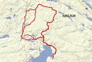
TRACK: KING RUN
AREA: Region: Sturgeon Falls, Field & Marten River
Just North of Tomiko Lake
DISTANCE: 45 km.
RATING: 5
ACCESS: On highway 64 North turn right at the Crystal Falls turnoff. Follow the road east to Crystal Falls but after crossing the bridge over the Sturgeon River, turn right and then left onto Tomiko road. Follow this road all the way to the end where you can park as noted on the map.
TRACK DESCRIPTION:
– For the first 3 km. the going is easy following an old logging road. This is maintained by cottagers in the area.
– The next section to Mosquito creek can be rough and muddy depending on the weather. It can make for slow going.
– The crossing at Mosquito creek can be easy with about 2 feet of water. However, during the spring this can more than double in depth. Note the remains of Anderson trapper shack just to the right. It was burnt down and arson was involved.
– Once over the creek the trail divides just at considerable blow down. To the left will be our return path to complete the loop. We turn right and continue on to a hut camp. This section can be challenging but will see plenty of moose tracks or maybe even a moose. At the camp, there is a perfect spot to have lunch.
– From here we follow the track on a very nice trail. Some of it is road but mostly it is a path and very good going. A suggested stop is at the pole line.
– 2.5 km. before the pole line turn left and this is an alternative trail for the ride passing through beautiful hardwood stands. About 2 km. in there is a wet section that can be avoided with a corduroy road to the left. Just beyond this turn left and the good trail eventually returns to the pole line.
– Next section follows the pole line for about 5 km. heading south. Good going.
– Turn east and travel 4 km along a logging road heading back to Mosquito Creek.
– Alternatively you can pass next to the hunt camp and come out at the end of the logging road that is mentioned above. Going can be difficult.
– The last section to Mosquito can be challenging for it is just a trail cut out of the bush.
– Back track to our vehicle.
HISTORY: This track has a history of being challenging and often there are wet and muddy sections. Because of numerous blow-down trees it is wise to have a chainsaw on hand.
This ride was last done in 2019.
NOTE: Because there are really two ways to do this ride, there are two gpx files: King#1 and King #2.
Revised January 18, 2020