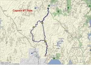
TRACK: CAPREOL #1
AREA: Region: Capreol North
North of Capreol
DISTANCE: 140 km
RATING: 3
ACCESS: You can access this ride by travelling to Capreol.
1. From Capreol travel approximately 7 km. on highway 545.
2. Turn right on Portelance Road. At the corner it says to Rocky’s and to the
Wanapitei Reserve. Travel approximately 7 km.
3. Continue straight, not turning at Rocky’s turnoff, on Gauthier Lumber Road
for 20 km. to the parking area. The first parking area saves travelling by
vehicle on the logging road.
TRACK DESCRIPTION:
– This ride follows the Wanapitei River for close to 30 km. Locals call this the
North River.
– Cross the bridge and continue on to the head waters of the Sturgeon River.
The bridge has been removed and you can’t go any further.
– Return back on your tracks to the bridge crossing the North River and turn to
the right.
– Instead of following the pole line continue straight ahead and follow the
logging roads in the cutover area.
– Good idea to use your GPS all the way back to the parking area.
For this ride extra gas is required.
This ride is a new one to the club.
01/23/2018