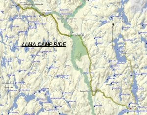
TRACK: ALMA CAMP RIDE
AREA: Hwy 805 North
North of River Valley
DISTANCE: 75 km.
RATING: 3
ACCESS: On highway 539A turn left on hwy 805 and travel up to Grassy Lake
(Wawiashkashi Lake on map). From Hwy. 805 turn left continuing 2 km. to a
gravel pit to park. This is approximately 1.5 hours from Sturgeon Falls.
CONCERNS: This ride has been kept in our book for historical purposes for it was last
done in 2008. At that time there was lots of chainsaw work to be done.
Anyone attempting this ride can expect the worst.
TRACK DESCRIPTION:
– Leaving the parking area continue northwest up the logging road. Going is
excellent and continue right up to Lower Goose Falls. This is an excellent spot
for a break.
– For the next 5 to 6 kilometres continue on until a major fork in the road. To
the left will lead to Chiniguchi and Wolf Mountain. Make a right and go to the
Sturgeon River which is close at hand.
– This is where the trail becomes interesting. At low water you can cross the
Sturgeon River leading to what the old timers called Vietnam. Stay to the left,
hugging the shore line and follow the trail.
– This ride was done in 2008 so it might be wise to bring a chainsaw. Going
could be slow but very manageable. Approximately half way there is a creek
to cross which could be challenging.
– Continue on to Alma Lake and the old logging camp. This is a perfect place to
have lunch. This camp existed in the late 1930’s but you can still see some of
the old foundations.
– To return back to the parking area, just retrace your path. It might be advisable
to bring goggles because the roads could dry up in the afternoon and become
dusty.
HISTORY: The club has had numerous organized rides in this area. This ride was interesting
in that a few members on the ride had begun their working lives working in this
camp. At 16 years of age this must have been an experience. The numerous
logging roads in this area make it a favourite for many riders from the West
Nipissing Community.
Revised 01/21/2018